| Salt mining took place for centuries in the Salzkammergut, long before the Salzburg Archbishops opened salt works around Hallein in 1200AD. In the earliest mines of the 5th and 4th centuries B.C., salt was extracted from the mountain in solid form. Salt was a valuable food preservative and almost as highly prized as gold, and foreign trade links were established. At the height of prehistoric mining, Dürrnberg salt was traded from the Baltic Sea as far as Italy, and from France as far as Hungary. From the 7th century BC, Celtic people lived in the area of today's salt mines around nearby Hallstatt, a large prehistoric salt-mining area. The "Hallstatt period," c.750 - 450 BC, is named after this region rich in archaeological evidence. With simple tools made of wood and bronze the Celts had built underground tunnels by hand up to 300 metres deep into the mountain to reach the valuable salt deposits. Salt was the main trade commodity used by the Celts. Dürrnberg is also home to a major Celtic site dating from 500-300 BC., and the mountainous area contains several large areas of ancient salt-mining dating from this period. In Dürrnberg, miners in 1573 and again in 1616 found "men in the salt," 2,000 years old mummified Celtic bodies perfectly preserved in salt. There were no signs of change other than that their skin had been colored brown by the effects of the salt. They unfortunately gave them "Christian burials," and thus, destroyed them. The grave of a Celtic chieftain buried with various treasures was discovered as recently as 1932. Clues to the ancient miners' diet from preserved feces were obtained. They ate millet, barley, beans, and apples. The salt they carried out was in leather rucksacks, and these ancient miners wore woollen clothes and leather slippers. |
| There was danger involved with every aspect of mining and great disasters occurred in the history of salt mining at Dürrnberg, but being a miner was still considered a privilege with good pay and modern job benefits, and the occupation tended to stay within families. Shift-work in the mines began on Monday morning and ended at lunchtime on Saturday. The miners, sitting on a "saddlecloth", slid down into the mine on a banister-like contraption. Up to the mid 19th century, the saline solution produced in the solution chambers of the mine was transported to the various Sudhäuser, or salt houses, in the town where it was processed. The main feature of the Sudhäuser was a big, flat, horse shoe shaped salt pan, a 'Sudpfanne', built of riveted metal which was suspended from the ceiling by hooks and supported underneath by brick columns. Boiling is the oldest method of extracting salt. The brine taken from the salt mine was heated until the water had completely evaporated and the pure white salt had crystallized. During the evaporation, which ran from Monday until Saturday, the hot and damp salt was pulled from the pan every two hours and put into conical wood containers, tapped down, and after a short time pulled from the form. These heavy salt plugs were dragged by carriers into the baking ovens, 'Pfieseln'. After the drying, the salt cones were smashed into thumb size pieces for transportation barrels. Other aspects of the industry involved the packing and transport of salt. Boiling houses for the salt were built of local lumber, and as the sources of fuel dwindled, the boiling houses were moved. This enriched the lumber trade in the area. The wood industry was crucial for Salt pans, barrels and other implements. The salt springs which emerged from horizontal tunnels in the valley sides were actually the ancient galleries into the old flooded salt mines that had been worked in prehistoric times, a fact that later miners were unaware of. One tunnel the miners worked in went all the way through from Dürrnberg to Berchtesgaden, and disputes over property rights and boundaries were common among the neighboring rulers. Salt mining at Dürrnberg was ended in 1989. |
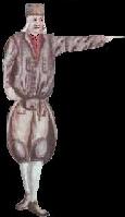
| The Knappenfahne of 1586 shows the unique sword dance of the Dürrnberg miners. Paid to entertain the Archbishops, they danced by torch light in a round chain dance dressed in their uniforms, depicting the skills and customs of their work in 12 scenes. In the 16th and 17th Century, 16 dancers took part and the performance took from 45 to 90 minutes and included a bow of respect to sponsors and guests. It eventually grew to include 20 dancers, up to 30 torch holders and included a 50 man chorus. Such dancing had been around since ancient times in German regions, and was even recorded by the Roman historian Tacitus who commented: “One public diversion which is constantly exhibited at all of their meetings, the young, whose men by frequent exercise have attained great perfection in that pastime, strip themselves, and dance among the points of swords and spears with the most wonderful agility, and even with the most elegant and graceful motions. They do perform this dance for hire, but usually for the entertainment of spectators, where applause is sufficient reward.” |

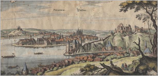
| The ancient area of Passau was settled more than 7,000 years ago. Barbarossa's armies once stopped in there on their way to the crusades and Alexander Humboldt described Passau as “one of the seven most beautifully situated cities in the world”. The Danube, Ilz and Inn (or En) rivers meet at the same point in Passau, a city known in ancient times as Celtic Boiodurum, then later as Batavis, and as part of Roman Noricum, Bazzawa, then ultimately Passau. A bishopric in the fifth century, Passau evolved into the largest in the entire Holy Roman Empire, its influence extending even into present-day Hungary. The Inn runs north-eastward, entering Austria, and from Landeck eastward through the Tyrol where it passes the border to Bavaria near Kufstein. In Bavarian territory the river runs northwards and then it turns east and is enlarged by two major tributaries, the Alz and the Salzach. From here to where it finally enters the Danube, it forms the border between parts of Germany and Austria. The River Salzach, an eastern tributary of the Enns, is the main river of Salzburg. Its source is in the Kitzbühel Alps near Krimml, Salzburg. From here it runs northwards and passes the cities of Hallein and Salzburg. Then it forms the border between Bavaria, Germany and Austria for almost 43 miles. Beautiful little castles and hamlets once dotted the riverside. The river winds past the numerous toll stations where the shipments were taxed by the various princes of the region. Cities on the banks include Burghausen, the biggest city of the district Altötting in Bavaria. It probably developed between the 6th and 8th century at the river bank to take advantage of the salt trade. On top of the mountain ridge perches the longest castle of Europe, 1.043 meters in length. The Salzach River finally joins the Inn near Braunau. Some salt which arrived from the Inn, Salzach and Danube rivers was transported from where the rivers converged at Passau upstream to Regensburg and downstream to Vienna. Half of the salt went on to Bohemia all the way to Prague and even regions well beyond. The Danube River was then navigable up to the town of Ulm, and people used either rafts or river barges. Shipping downriver was called "Naufahrt", shipping upriver "Gegenfahrt". Its main cargos were once salt from the towns of Hallein, Berchtesgaden, Reichenhall and Traunstein, and wood and iron from the Oberpfalz region. It was also the major supply line in the wars against the Ottoman Empire, especially during the two sieges of Vienna. At the end of the 10th and beginning of the 11th century, Bohemian merchants started loading salt in Passau rather than in Linz after Emperor Heinrich II donated a large part of the northern woods towards the Bohemian border to the monastery of Niedernburg in 1010. This enabled the monastery to collect the so called "Bohemian Toll" between Inn and Danube. They gave half of the toll to Passau and it helped erect new public buildings and to maintain the old and also maintain bridges. When laws regulating the salt trade were drawn by Bishop Otto, he ruled that salt which was transported on the Inn had to be stored and offered for sale in Passau for at least three days and it went through several "processing stations" there which were in the hands of businessmen called "Salzfertiger" who ran the large warehouses for the salt storage. These merchants established a powerful monopoly against their competition from Bohemia and Austria. After the three days and the customs clearance, the salt could continue its way toward the north and east. The trade route from Passau to Bohemia was one of the "Golden Paths." Some salt which arrived from the Inn, Salza and Danube was transported from Passau on the water route upstream to Regensburg and downstream to Vienna. Half of the salt went on to Bohemia all the way to Prague. The citizens engaged in the salt trade grew wealthy, and the salt duty was a substantial source of income for the local bishops. The salt ships put in at Passau behind the Schaiblingsturm located at the banks of the Inn River in Passau, which dates back to the 14th century. It was part of the old salt boat harbor in Passau, and there the salt had to be stored in a salt barn. The 16th century salt ships had a capacity of 14 to 65 metric tons. Each boat carried a load of approximately three hundredweights. In 1500, the crew of a small salt ship consisted of about eleven, although a big group of ships consisted of fifty seven or so. Sources of danger of river travel were rocks, sand bars, whirlpools, low bridges, ice floes and fog. Spring flooding was a main danger along this river with the many tributaries starting in the Alps, and a main obstacle for ships were the rapids near Passau and the low Stone Bridge in Regensburg. The 15th century was Passau's great age and there was then a busier traffic on the Danube and Inn Rivers than the traffic on the Rhine River. When Bohemia came under Habsburg rule in 1526, Passau's salt trade came to an abrupt end when the Bavarian Duke set up his own loading point for salt close to Passau in the "Hofmark of St. Nikola". In 1534, Duke Maximilian of Bavaria and the Archbishop of Salzburg negotiated that the output of the salt mine in Hallein would from now on belong to Bavaria and that Bohemia would now receive its salt from Austria. All salt imports to Passau were forbidden in 1706, and Passau lost the last vestiges of its tremendous economic importance. It simply faded into a pretty, lazy town by the rivers. |
| PASSAU: An Old Salt Town |

| Above: Passau in the 16th century; Below A salt boat in Hallein (click) |
| There was a long time, until 1200, during which the mine on the Dürrnberg was again. Medieval miners used hammers and iron pickaxes for building galleries. Since the 13th Century, nearby Hallein shipped salt by cart to Frankonia, Bohemia, present day Lower Austria and Moravia. The salt crossed the rugged Tauern mountains and reached as far as Carinthia and East Tyrol. However, over half of its output was shipped by boat to the port at Passau from Hallein where 119 tons of Dürrnberg salt were shipped daily each spring when the Salzach river was navigable all the way to the Danube. Ship building was, therefore, a side industry. The Schwazer Bergbuch is an illuminated, handwritten manuscript produced in 1556 for a small, select circle. It is preserved in four versions and provides insight into mining of the ancient times. In the same year as the oldest copy of the book appeared, so did Agricola's mining industry manual. Theories are that the book was made by mountain clerks of the court in Schwaz to attract financial investors and trading partners. Part one contains the "Schwazerisch Erfündung", the rules for miners, regulation of mine property, the supervision of the mountain and work and social aspects of the mining industry. Part two is concerned with notes to the mining industry, descriptions of the specific locale of the mining industry, different devices and the tasks of the mountain officials as well as the remuneration of the miners. The third part is the oldest illustrated mine industry encyclopedia, and the fourth is a compilation of the jurisdiction of the Schwazer mountain court. Some of the images from the book, below (click) |


| The Mines at Dürrnberg |
| Dürrnberg is called Bad Dürrnberg today for its spas which came about when mining ceased.It is part of the administrative district of the Tennengau, named for the Tennen massif, a division of the Salzach Valley south of Salzburg framed by rolling hills, woodlands, waterfalls and some historic houses called the Tennengauer Einhöfe. Living accommodations were quite simple for the miners and farmers in the area around the mines. If a house and its farm buildings were built parallel to each other, they were called a pair-höfe. If they are combined under one roof, they are called an Einhöfe, hof meaning hall or court. Aside from the Einhof type, there were also Zwiehof, Haufenhof, Gruppenhof, Mehrseithof, Hakenhof, Streckhof and others. The Dürrnbergers of the 16th and 17th centuries lived in these large one-building farmsteads with farm buildings and living units combined under one roof and linked with a connecting hall. In the Einhöfe, sometimes two families lived under the one roof in a “common house” with their own rooms above, and kitchens and stable areas opening to the unlocked central common corridor on the ground floor. These large houses were heated by large, decoratively tiled wood fireplace-furnaces which existed from the 16th century, with a smoke oven and sleeping shelf. |
| Country Living of the Miners |


| Salt Mining and Dürrnberg |